Columbia rising: a visit to the Vancouver, WA waterfront
By Brian Libby, Portland Architecture
Published
As I arrived last Wednesday at Vancouver, Washington's newly redeveloped stretch of Columbia River waterfront, it seemed like a scene out of a movie.
Though rain and fog had blanketed the region, in the distance to the west I could still make out the industrial facility on the edge of the property: the LaFarge North America concrete factory. As I walked towards the development's quartet of new buildings in various stages of completion, a World War II-era fighter plane zoomed overhead at low altitude as if ready to dive-bomb. Turns out it was merely in the process of landing at Pearson Field, the small airport just east of here. Across the Columbia, a steady stream of commercial jet planes descended towards PDX. Just south of this new waterfront enclave, traffic whizzed by on the Interstate Bridge, and more slowly, a succession of barges and small watercraft cruised by on the river itself. And to the north, from time to time a freight train would sound its horn as it continued along the trestle that has long severed Vancouver from its waterfront.
Quite a crossroads.
There is a lot to like about The Waterfront, as this new development officially known. The developers' approach to the mix of architecture, landscape and urban design is quite different than what has transpired in Portland's most comparable 21st century riverside neighborhood: South Waterfront. More on that soon. But it's worth saying first that the most impressive thing about The Waterfront, or at least the most welcome aspect, is that it exists at all.
For the past century or so, this stretch of the Columbia, just west of the Interstate Bridge and just south of downtown Vancouver, has been cut off from public access and devoted exclusively to industrial use. In that way, The Waterfront is part of the larger story of American cities reclaiming their industrial waterfronts and giving them back to public use. In Vancouver's case, this land was established as a saw mill and lumber finishing plant in 1911, then in 1928 it became home to the Columbia River Paper Company, making pulp and paper products. In 1962, the Boise Cascade Corporation assumed ownership of the facility and produced paper products there until 2006.
It took another 12 years before developers from Gramor Development were able to break ground.
Boise Cascade first had to remove its paper mill, then clean up contaminated soils. Then there was the pesky fact of the railroad trestle, which has long enacted a terrible cost to Vancouver by severing the city from its greatest asset: its Columbia River waterfront. The trestle has amounted to a kind of Berlin Wall or something like Trump's ridiculous and race-baiting proposed border wall with Mexico: one big warning that says "go away" to not only people but to economic opportunity. (At least Vancouver never tear-gassed anyone.) The developers and their partners had to convince Vancouver's city council to approve rebuilding the trestle in order to punch roadway openings through it, a $44 million investment.
Did I mention it was a rainy Wednesday when I visited? This is noteworthy because, while the primary multi-story residential and office buildings (across the street from the main promenade) are still under construction, the two waterfront restaurants when I visited them last week (part of a pair of two-story retail buildings) were packed. And while my French dip was tasty enough, I don't think it's just because of the food.
Walking the site with Gramor president Barry Cain, we talked about how to approach a development like this, where the waterside is the obvious attraction but ultimately it's meant to be a fairly high-density urban neighborhood. In Vancouver's case, Cain's team decided they wanted to emphasize public access. Whereas South Waterfront's riverside couldn't be quieter, its residential towers coming almost all the way to the riverbank without any retail amenities to attract the public and a fairly narrow walkway to hold them if they do arrive, here in Vancouver the developers hired an acclaimed Vancouver, British Columbia landscape firm, PWL Partnership, to design a waterfront promenade that features over half a mile of walking trails as well as beach access at its western edge.
Thinking about how empty South Waterfront can feel along the riverside, or even the similar problems plaguing Tom McCall Waterfront Park, where Naito Parkway remains under-utilized, I couldn't help but wonder if they could have been enlivened by this approach. Particularly in South Waterfront, I think we made a mistake not making the riverside more public-oriented with retail, a large promenade and smaller buildings.
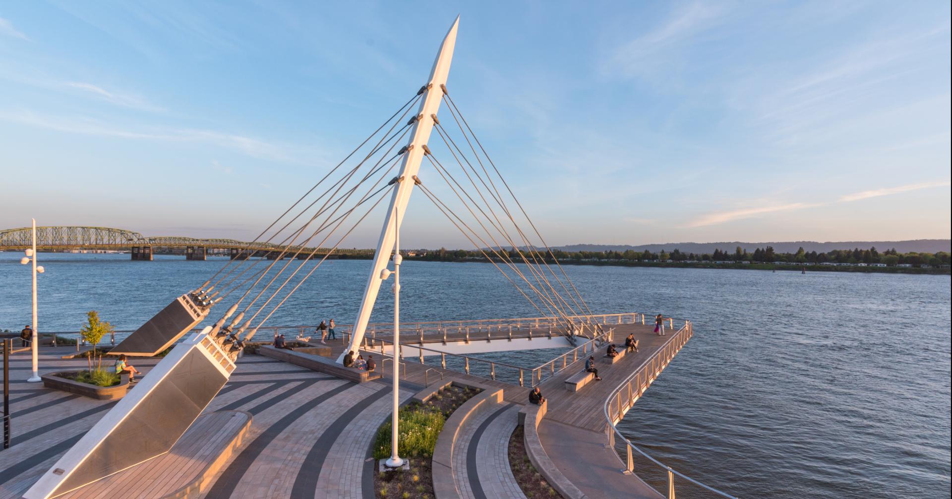
The undeniable centerpiece of PWL Partnership's waterfront park, however, is what's known as the Grant Street Pier. Situated between the pair of two-story buildings fronting the park, it extends the promenade 90 feet out over the Columbia River, suspended by cables on the shore in order to avoid driving support poles into the riverbed. The Grant Street Pier really does give one the sensation of being out over the water, much like being at the very front of a sailing ship. Don't worry: I didn't do a Leonardo DiCaprio impression, shouting to Cain and my PR contact, Heather Villanueva, that I was king of the world (a la James Cameron's rapturously schmaltzy Titanic). But it did feel transporting to stand there on the pier, as if I'd left the shore behind.
In fact, as I stood on that cable-stay-suspended pier over the river, a larger thought occurred to me: that Vancouver has in effect staked a claim to the Columbia River's banks that Portland has never convincingly made.
The cables that support the pier are pretty big and heavy, as if to communicate an extra dose of pride at suspending the pier over the water. But the effect really is compelling. I liked not only being suspended over the Columbia but the triangle of space that is created between the bank and the diagonals of the pier.
Portland is technically situated at the confluence of the Willamette and Columbia, but in reality the city center is of course a few miles downriver on the Willamette from where the two rivers join. Portland's side of the Columbia has shops, restaurants and even a hotel clustered at Jantzen Beach on Hayden Island, but only at the Red Lion Hotel just east of the Interstate Bridge are there waterside views, and that's not even directly comparable to a waterfront park and pier. When I was standing on the Grant Street Pier last Wednesday in Vancouver, west of the bridge, I looked directly across the Columbia and saw cheap mobile homes on the Portland side.
It begs the question: even though central-city Portland lies along the Willamette, and even though the Portland side of the Columbia waterfront is not a high-density area, why have we so missed the opportunity to make the Vancouver waterfront something special? After all, cities throughout America are reclaiming their waterfronts. To an extent, we've already done that in Portland by building the South Waterfront district and carving out the Eastbank Esplanade beside the I-5 freeway hugging most of the east-side waterside. If the area around OMSI develops further, or the Zidell Yards just north of South Waterfront, that sense of embracing the water could increase. Yet we in Portland have still dropped the ball on making the Columbia River waterfront a place where people want to be. I mean, most of Jantzen Beach is just a woefully outdated shopping mall of the sort we embraced back in the 1970s and '80s, surrounded by big-box retail establishments and seas of parking lots. Jantzen Beach is effectively a suburban wasteland. But it has something to offer that Beaverton, Hillsboro and Gresham do not: a natural amenity in the form of one of America's most iconic rivers, where Lewis & Clark once traveled on their way to the Pacific. And what buildings do we devote to this priceless riverfront? Sure, there is a marina east of the Interstate Bridge, but for the most part, we turn our backs to the river.
The Waterfront, as Vancouver's development is known, starts with some unremarkable architecture, at least on the surface. Phase 1 includes the two waterside retail buildings as well as four additional buildings across Waterfront Way — designed by a combination of three local firms: Portland's Ankrom Moisan and LRS Architects, and Vancouver's LSW Architects. If I'm not mistaken, LRS designed the pair of two-story restaurant buildings fronting the property; LSW designed Block 8, which features brick-clad, market-rate apartments over retail and a west-facing, third-floor courtyard; and Ankrom Moisan designed Block 6 West and Block 6 East, which feature luxury apartments and offices, respectively. Of these, I suppose I like Block 8 best, but all five buildings to my eyes look a bit corporate and suburban, as do some of the upcoming buildings such as Block 4, the Hotel Indigo and the Residences at Kirkland Tower, designed by Otak for Kirkland Development (which apparently has named a portion of the building for itself).
Yet at least for me, the architectural aesthetics do not necessarily take away from the overall success of the development because the scale seems right. Award-winning firms might have put cooler-looking buildings here, but very well might have arrived with the client at the same decision about how tall to go — or, more accurately, how short to go. Instead of placing tall buildings along the waterfront, like in SoWa, they start with small structures. The dual retail buildings on the water are two stories. The aforementioned buildings on Waterfront Way are mostly five to seven stories. In subsequent phases there will be additional blocks constructed (there are 21 in all) of gradually greater heights as one moves away from the river.
Given what an epiphany The Waterfront is—how it extends downtown Vancouver to the river—it's natural to look east and west in contemplation of how the city might extend this connection.
To the west are industrial and port facilities. In general, we have to let industry retain portions of the riverfront for loading and unloading cargo. It's an essential component in our economic engine. Yet it doesn't seem absurd to let the public and downtown Vancouver claim a little bit more. Industrial/port acreage covers vastly more land along the Columbia in this area west of the bridge than this new development and promenade do.
To the east, there are two barriers between Vancouver and the river: the SR 14 highway and Pearson Field. It's pretty doubtful that the highway is going to go away any time soon, but eliminating Pearson—which, as it happens, is directly across the river from another airport—would allow the adjacent Fort Vancouver to the north to connect with cityscape that gets pretty close to the Columbia, and coupled with some kind of path above or below the highway, it could connect to some existing waterfront area further east still that includes a residential neighborhood and a waterside McMenamins.
There is actually one extension of this riverside area coming. The Port of Vancouver owns six acres next door to The Waterfront, and is redoing the pier there to make it suitable for cruise ships. It's not so difficult to imagine a future where more ships choose to stop here than to continue down the Willamette into Portland, because Vancouver will be the place where a lot of tourists go to interact with the Columbia.
The developers commissioned Portland's Johnson Economics to perform an economic study of Waterfront Vancouver's impact. Johnson found the total economic impact for Clark County from the development to be $1.2 billion. Normally I'm not one to cite economic figures as it relates to justifying a development, because trotting out figures about construction jobs can distract us from the question of whether this is a good design and good place-making. I mean, Portland's long-awaited convention center hotel will do a lot to help bring more big events to the city, but that doesn't change the fact that it's ugly. The City of Portland might generate a lot of jobs and economic impact building out the former post-office land on NW Broadway, but if it's homogeneous and antiseptic, who cares?
But in this case, the $1.2 billion speaks to the fact that Vancouver is perhaps more than just a Portland suburb. There's more of a true therethere, more so than Gresham or Beaverton or Tigard or Hillsboro. All those suburbs do have modest downtowns of their own and are carving out more walkable spaces. Yet being on the other side of the Columbia has always, of course, set Vancouver apart. It just always stopped short of what it could be — because it stopped short of the river. With the railroad trestle and the SR 14 highway and the lack of any local bridges, you'd almost think these were battlements, almost like Nike's berm can feel like sometime. Yet claiming that riverfront, no matter how mediocre the buildings themselves may be, is almost indeed like a military victory. This isn't June 6, 1944, but I do feel like Vancouver has established a beachhead that could alter the city's history.
